
Mapa Panama serves as an essential tool for understanding the diverse landscapes, vibrant cities, and intricate details of this Central American gem. Nestled between Costa Rica and Colombia, Panama is a country of remarkable diversity, from its bustling capital to its lush rainforests and iconic canal.
This guide delves into the various types of maps that reveal Panama’s geography, culture, and attractions, offering insights for travelers, researchers, and curious minds. Whether you’re planning a trip or studying the region, exploring Panama through its maps unveils a world of natural beauty and historical significance.
Understanding Panama Geography Through Maps
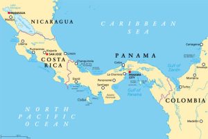
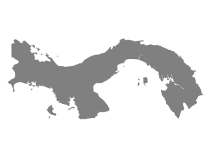
Panama’s unique position as the bridge between North and South America shapes its geography, culture, and economy. A map of Panama highlights its narrow, S-shaped landmass, stretching approximately 772 kilometers from east to west. The country spans 75,517 square kilometers, with a coastline along both the Caribbean Sea and the Pacific Ocean. This strategic location makes Panama a global hub for trade and travel, most notably through the Panama Canal map, which showcases the 82-kilometer waterway connecting the two oceans.
Panama’s terrain is diverse, featuring coastal plains, rolling hills, and rugged mountains. The central spine, known as the Cordillera Central, includes Volcán Barú, the highest point at 3,474 meters. A Panama physical map illustrates these elevations, with lush rainforests covering nearly 40% of the land and mangroves lining the coasts. The country’s tropical climate, with distinct wet and dry seasons, influences its ecosystems, from coral reefs to cloud forests.
Maps also reveal Panama’s division into ten provinces and five indigenous comarcas, each with distinct cultural and geographic traits. A Panama provinces map outlines these administrative regions, such as Chiriquí’s highlands or Bocas del Toro’s island archipelago. These maps are invaluable for understanding regional differences and planning travel across the country.
Exploring Panama City with a Detailed Map
The capital, Panama City, is a vibrant metropolis blending modern skyscrapers with colonial history. A Panama City map is essential for navigating its dynamic neighborhoods, from the historic Casco Viejo to the bustling financial district. Key landmarks like the Metropolitan Cathedral, Amador Causeway, and the Miraflores Locks of the Panama Canal are often highlighted on a detailed Panama map. These maps help visitors locate museums, restaurants, and transportation hubs, making it easier to explore the city’s cultural and economic heart.
For travelers, a Panama tourist map pinpoints attractions like the Biomuseo, designed by Frank Gehry, or the vibrant nightlife of Calle Uruguay. Public transportation, including the Metro system, is also marked, aiding navigation in this fast-growing urban center. Whether strolling through historic sites or enjoying coastal views, a city map ensures you don’t miss Panama City’s highlights.
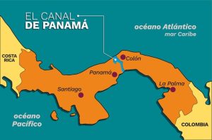
The Panama Canal: A Marvel on the Map
The Panama Canal map is perhaps the most iconic representation of Panama’s global significance. Completed in 1914 and expanded in 2016, the canal is an engineering feat that facilitates 6% of world trade. Maps of the canal detail its locks—Gatún, Pedro Miguel, and Miraflores—and the artificial Gatún Lake, which vessels traverse to cross the continental divide. These maps often include depth charts and transit routes, illustrating the canal’s complex operations.
For visitors, canal maps highlight observation points like the Miraflores Visitor Center, where you can watch massive ships pass through the locks. A Panama location map often places the canal in context, showing its path from Colón on the Caribbean side to Panama City on the Pacific. Understanding the canal’s layout enhances appreciation for its role in global commerce and Panama’s history.
Navigating Panama’s Provinces with a Provinces Map
A Panama provinces map is crucial for exploring beyond the capital. Panama’s ten provinces—Bocas del Toro, Chiriquí, Coclé, Colón, Darién, Herrera, Los Santos, Panamá, Panamá Oeste, and Veraguas—each offer unique landscapes and cultures. For example, Chiriquí’s highlands, shown on a Panama geography map, feature coffee plantations and hiking trails around Volcán Barú. Bocas del Toro, an archipelago, is a haven for beach lovers and snorkelers, with maps highlighting islands like Isla Colón.
Indigenous comarcas, such as Guna Yala, are also marked, showcasing areas where indigenous communities maintain autonomous governance. These maps help travelers plan routes to remote regions like Darién, known for its dense jungle and biodiversity. A Panama road map complements this by detailing highways and secondary roads, essential for road trips across the country’s varied terrain.
Political and Physical Maps for a Deeper Understanding
A Panama political map outlines administrative boundaries, including provinces, comarcas, and major cities. It’s useful for understanding governance and regional identities. For instance, Guna Yala’s distinct status as an indigenous territory is clear on such maps, emphasizing its cultural autonomy. These maps often include population data, showing Panama City’s dominance with over 1.5 million residents in its metropolitan area.
Conversely, a Panama physical map focuses on natural features—mountains, rivers, and coastlines. The San Blas Islands, part of Guna Yala, appear as a scattering of dots in the Caribbean, while the Darién Gap’s rugged terrain is evident in the southeast. These maps are vital for geographers and adventurers studying Panama’s ecosystems or planning treks through its national parks, which cover 25% of the country.
Interactive and Satellite Maps for Modern Exploration
Technology has transformed how we explore Panama. An interactive map of Panama allows users to zoom into specific regions, view real-time traffic, or overlay data like weather patterns. These maps, often available on mobile apps, are perfect for travelers seeking dynamic navigation tools. For example, you can explore Panama City’s streets or remote trails in Coiba National Park with a tap.
A Panama satellite map offers a bird’s-eye view, revealing deforestation patterns, urban sprawl, or coral reefs. These maps are invaluable for environmentalists studying Panama’s biodiversity, which includes over 10,000 plant species and 1,000 bird species. Satellite imagery also highlights the canal’s infrastructure and coastal developments, providing a modern perspective on Panama’s landscape.
Planning Travel with a Panama Tourist Map
For visitors, a Panama tourist map is a must-have. It highlights attractions like the Soberanía National Park, where you can spot sloths and toucans, or the Pearl Islands, a short flight from Panama City. Cultural sites, such as the Guna Yala’s indigenous villages, are also marked, offering insights into traditional lifestyles. These maps often include practical details like hotels, ferry routes, and dive sites, making trip planning seamless.
A Panama travel guide map goes further, suggesting itineraries for beaches, jungles, or cultural tours. For instance, a route might start in Panama City, head to Bocas del Toro for island hopping, and end in Boquete for coffee tours. These maps ensure travelers experience Panama’s diversity, from surfing in Santa Catalina to exploring colonial forts in Portobelo.
Road and Transportation Maps for Seamless Travel
A Panama road map is essential for those driving across the country. The Pan-American Highway, stretching from the Costa Rican border to Yaviza in Darién, is the backbone of Panama’s road network. Maps detail rest stops, gas stations, and scenic routes, like the road to El Valle de Antón, a volcanic crater town. They also show secondary roads to remote areas, though some, like the Darién Gap, remain inaccessible by car.
Public transportation routes, especially in Panama City, are often included. The Metro and bus systems connect key areas, while ferries serve islands like Taboga. For adventurers, maps highlight trailheads for hikes in national parks, ensuring safe navigation through Panama’s wild landscapes.
FAQs About Maps of Panama
- What is the best type of map for exploring Panama’s provinces?
A Panama provinces map is ideal, as it outlines administrative boundaries and highlights major towns, roads, and attractions in each province, making it easier to plan regional travel.
- How can a Panama Canal map help tourists?
A Panama Canal map shows the canal’s locks, visitor centers, and transit routes, helping tourists plan visits to observation points like Miraflores and understand the canal’s layout.
- Are interactive maps of Panama useful for travelers?
Yes, an interactive map of Panama offers real-time navigation, zoomable details, and overlays for traffic or weather, perfect for exploring cities or remote areas on the go.
- What does a Panama physical map show?
A Panama physical map displays natural features like mountains, rivers, and coastlines, highlighting areas like Volcán Barú or the Darién jungle for geographers and adventurers.
- How can a Panama tourist map enhance a trip?
A Panama tourist map pinpoints attractions, hotels, and activities, such as beaches in Bocas del Toro or cultural sites in Casco Viejo, simplifying travel planning.
- What makes a Panama satellite map unique?
A Panama satellite map provides aerial views of terrain, urban areas, and ecosystems, useful for studying environmental changes or planning outdoor activities.
- Where can I find a detailed Panama road map?
A Panama road map is available through travel agencies, online platforms, or tourism offices, detailing highways, secondary roads, and key stops for road trips.
Conclusion Mapa Panama
Mapa Panama opens a window into the country’s rich tapestry of landscapes, cultures, and history. From the urban sprawl of Panama City to the untouched jungles of Darién, maps are indispensable tools for exploration.
Whether you’re tracing the Panama Canal’s path, navigating provincial roads, or planning a beach getaway, the right map—be it political, physical, or interactive—enhances your journey. By offering detailed insights into Panama’s geography and attractions, these maps empower travelers and researchers to discover the heart of this Central American treasure.