Map of Florida Panhandle serves as an essential tool for exploring the region’s stunning coastline, vibrant cities, and natural wonders. Stretching from Pensacola to Apalachicola along the Gulf of Mexico, this Florida Panhandle map covers roughly 200 miles of Northwest Florida, known as the Emerald Coast for its turquoise waters and white sand beaches.
A detailed map of Florida Panhandle reveals key cities in Florida Panhandle map, major highways, and attractions, making it indispensable for travelers seeking Florida Panhandle beach map details or planning road trips with a Florida Panhandle road map.
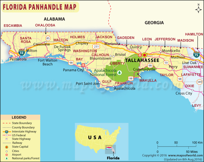
Geography of the Florida Panhandle
The Panhandle of Florida map outlines a region bordered by Alabama and Georgia to the north, the Gulf of Mexico to the south, and the Apalachicola River to the east. Spanning eight counties—Escambia, Santa Rosa, Okaloosa, Walton, Bay, Gulf, Franklin, and Wakulla—the Panhandle is distinct for its blend of coastal beauty and inland diversity.

The Northwest Florida map highlights flat coastal plains, pine forests, and over 400 miles of shoreline, including Florida Panhandle beach map areas like Destin and Panama City Beach. Major geographical features include:
- Coastal Areas: Home to sugar-white beaches and emerald waters, ideal for Florida Gulf Coast Panhandle map exploration.
- Inland Regions: Feature rivers like the Choctawhatchee and forests like Blackwater River State Forest, visible on a detailed map of Florida Panhandle.
- Barrier Islands: Santa Rosa Island, St. George Island, and Perdido Key, key points on a Florida Panhandle beach map.
This diverse geography makes the map of Florida Panhandle a vital resource for travelers and locals alike.
Key Cities in Florida Panhandle Map
A cities in Florida Panhandle map highlights major urban centers, each offering unique attractions and cultural vibes. Here are the primary cities:
- Pensacola: Located in Escambia County, known for its historic downtown, Naval Air Station, and Pensacola Beach. A tourist map of Florida Panhandle marks its position on the western edge.
- Destin: Dubbed the “World’s Luckiest Fishing Village,” situated in Okaloosa County, famous for fishing charters and Henderson Beach State Park.
- Panama City Beach: In Bay County, a hub for spring breakers and families, with 27 miles of beaches and St. Andrews State Park.
- Fort Walton Beach: Near Destin, known for the Gulfarium Marine Adventure Park and Okaloosa Island.
- Tallahassee: The state capital in Leon County (technically outside the Panhandle but often included), home to Florida State University and cultural sites.
- Apalachicola: In Franklin County, a historic fishing town known for its oysters and quaint charm.
These cities, plotted on a detailed map of Florida Panhandle, serve as gateways to the region’s attractions, accessible via major highways like I-10 and US-98.
Major Highways and Florida Panhandle Road Map
A Florida Panhandle road map is crucial for navigating the region’s extensive road network. Key routes include:
- Interstate 10 (I-10): Runs east-west from Pensacola to Tallahassee, connecting major cities in Florida Panhandle map like Crestview and Marianna. It’s the primary inland route.
- U.S. Highway 98: Follows the Gulf Coast, linking Florida Panhandle beach map destinations like Destin, Panama City Beach, and Apalachicola. It’s ideal for scenic drives.
- State Road 30A: A 24-mile stretch in Walton County, connecting beach towns like Seaside and Grayton Beach, a highlight of tourist map of Florida Panhandle.
- U.S. Highway 231: Runs north-south, connecting Panama City to inland areas like Dothan, Alabama.
These routes, clearly marked on a Florida Panhandle road map, make road trips efficient, whether exploring urban centers or Florida Gulf Coast Panhandle map beaches.
Florida Panhandle Beach Map: Coastal Highlights
The Florida Panhandle beach map is a centerpiece for visitors, showcasing world-renowned beaches along the Florida Gulf Coast Panhandle map. Key beach destinations include:
- Pensacola Beach: On Santa Rosa Island, known for its white sand and Gulf Islands National Seashore, marked on any Florida Panhandle beach map.
- Navarre Beach: A quieter spot in Santa Rosa County, with a 1,545-foot fishing pier and pristine shores.
- Destin and Fort Walton Beach: In Okaloosa County, featuring Henderson Beach State Park and emerald waters.
- Panama City Beach: Offers 27 miles of coastline, with St. Andrews State Park and Shell Island, a must-see on a tourist map of Florida Panhandle.
- Grayton Beach: In Walton County along Scenic 30A, home to a state park with rare coastal dune lakes.
- Cape San Blas: In Gulf County, a secluded gem with St. Joseph Peninsula State Park, ideal for a detailed map of Florida Panhandle.
- St. George Island: In Franklin County, known for its unspoiled beaches and state park.
These beaches, plotted on a Florida Panhandle beach map, offer swimming, fishing, and eco-tourism, making them central to the region’s appeal.
State Parks and Natural Attractions
A detailed map of Florida Panhandle highlights numerous state parks and natural sites, perfect for outdoor enthusiasts:
- Gulf Islands National Seashore: Spans Pensacola Beach and Perdido Key, offering beaches, historic forts, and hiking trails.
- Blackwater River State Park: Near Milton, ideal for canoeing, kayaking, and tubing, marked on Northwest Florida map.
- Topsail Hill Preserve State Park: In Santa Rosa Beach, with 3.2 miles of beach and coastal dune lakes.
- St. Andrews State Park: In Panama City Beach, featuring beaches, trails, and access to Shell Island.
- Apalachicola National Forest: The largest forest in Florida, covering 565,000 acres, perfect for hiking and wildlife viewing.
These sites, accessible via a tourist map of Florida Panhandle, showcase the region’s ecological diversity, from coastal dunes to inland forests.
Using an Interactive Florida Panhandle Map

An interactive Florida Panhandle map enhances navigation with features like zoomable views, real-time traffic updates, and clickable points of interest. Benefits include:
- Navigation: Plot routes between cities in Florida Panhandle map, such as from Pensacola to Destin, with estimated travel times.
- Attractions: Locate Florida Panhandle beach map spots, state parks, or dining options with detailed descriptions.
- Customization: Save favorite locations or create personalized itineraries for Florida Panhandle road map trips.
- Real-Time Data: Check road conditions or beach closures, especially during hurricane season (June-November).
Available through mobile apps or online platforms, an interactive Florida Panhandle map is ideal for planning Florida Gulf Coast Panhandle map adventures.
Practical Uses of a Map of Florida Panhandle
A map of Florida Panhandle serves multiple purposes for travelers and residents:
- Road Trips: Plan scenic drives along US-98 or 30A, connecting Florida Panhandle beach map destinations.
- Beach Exploration: Identify Florida Panhandle beach map spots like Cape San Blas for secluded getaways or Panama City Beach for family fun.
- Outdoor Activities: Locate state parks for camping, kayaking, or fishing, using a detailed map of Florida Panhandle.
- City Navigation: Explore cities in Florida Panhandle map like Tallahassee for cultural sites or Apalachicola for seafood dining.
- Event Planning: Map out festivals, such as the Pensacola Seafood Festival, using a tourist map of Florida Panhandle.
These applications make a Florida Panhandle map indispensable for any visit.
Tips for Using a Florida Panhandle Map
To maximize your map of Florida Panhandle experience, consider these tips:
- Choose the Right Map: Use a detailed map of Florida Panhandle for specific sites or an interactive Florida Panhandle map for real-time navigation.
- Check Seasons: Avoid hurricane season (June-November) for coastal trips, and check Florida Panhandle beach map for closures.
- Mark Key Routes: Highlight US-98 or 30A on a Florida Panhandle road map for scenic beach drives.
- Include State Parks: Add parks like St. George Island State Park to your tourist map of Florida Panhandle for outdoor adventures.
- Use Offline Options: Download maps for areas with poor cell service, like parts of Apalachicola National Forest.
These tips ensure effective use of a Panhandle of Florida map for seamless travel.
Common Mistakes to Avoid
When using a map of Florida Panhandle, steer clear of these errors:
- Ignoring Scale: Misjudging distances on a detailed map of Florida Panhandle can lead to unrealistic travel plans (e.g., Pensacola to Apalachicola is ~180 miles).
- Overlooking Rural Areas: Focusing only on cities in Florida Panhandle map misses gems like Cape San Blas.
- Not Checking Updates: Outdated Florida Panhandle road map may miss new roads or closures, especially post-hurricane.
- Neglecting Tides: For Florida Panhandle beach map, check tide schedules to avoid flooded beach access.
- Assuming Coverage: Some hidden beaches in the Panhandle of Florida lack cell service, requiring offline interactive Florida Panhandle map tools.
Avoiding these pitfalls enhances your navigation experience.
Exploring Beyond the Beaches
A tourist map of Florida Panhandle reveals attractions beyond Florida Panhandle beach map destinations:
- Historic Sites: Pensacola’s Fort Pickens or Seville Quarter for colonial history.
- Cultural Hubs: Tallahassee’s Museum of Florida History or Apalachicola’s historic downtown.
- Outdoor Adventures: Kayaking in Blackwater River or hiking in Topsail Hill Preserve.
- Festivals: Seafood festivals in Apalachicola or air shows in Pensacola, marked on a tourist map of Florida Panhandle.
- Wildlife: Spot dolphins or sea turtles at St. George Island, noted on Northwest Florida map.
These attractions enrich your Florida Gulf Coast Panhandle map experience.

FAQs About Map of Florida Panhandle
- What does a map of Florida Panhandle show?
A map of Florida Panhandle displays cities in Florida Panhandle map, beaches, highways, and attractions like state parks and marinas. - How can a Florida Panhandle beach map help plan a trip?
A Florida Panhandle beach map identifies top beaches like Destin or Cape San Blas, with access points and amenities. - What are the main highways on a Florida Panhandle road map?
I-10, US-98, and SR-30A are key routes on a Florida Panhandle road map, connecting coastal and inland areas. - Which cities are highlighted on a cities in Florida Panhandle map?
Pensacola, Destin, Panama City Beach, Fort Walton Beach, and Apalachicola are prominent on a cities in Florida Panhandle map. - How does an interactive Florida Panhandle map differ from a static one?
An interactive Florida Panhandle map offers zoomable views, real-time traffic, and customizable itineraries, unlike static maps. - What attractions are marked on a tourist map of Florida Panhandle?
A tourist map of Florida Panhandle includes beaches, state parks, historic sites, and festivals like the Pensacola Seafood Festival. - Why is a detailed map of Florida Panhandle useful for outdoor activities?
A detailed map of Florida Panhandle pinpoints parks like Blackwater River for kayaking or St. Andrews for camping.
Conclusion on Map of Florida Panhandle
A map of Florida Panhandle is your key to unlocking the treasures of Northwest Florida, from the sugar-white shores of Florida Panhandle beach map destinations to the vibrant cities in Florida Panhandle map.
Whether navigating scenic routes with a Florida Panhandle road map, exploring state parks on a detailed map of Florida Panhandle, or planning a beach getaway with a tourist map of Florida Panhandle, this region offers endless possibilities. With tools like an interactive Florida Panhandle map and careful planning, you can seamlessly explore Northwest Florida map highlights, ensuring a memorable journey along the Florida Gulf Coast Panhandle map.