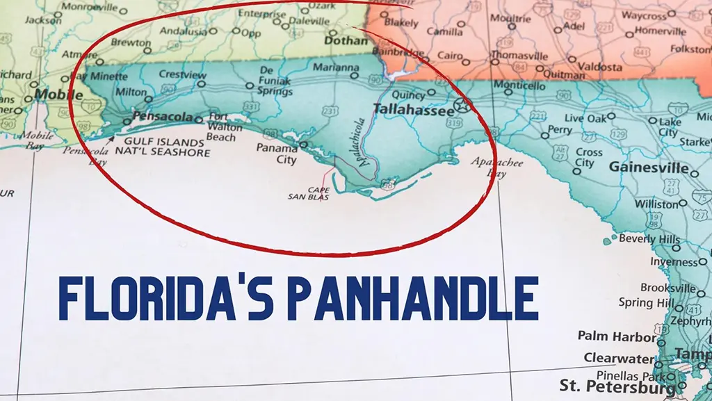
Map FL Panhandle reveals a vibrant stretch of Northwest Florida, known as the Emerald Coast, where sugar-white beaches, emerald waters, and charming towns create a captivating destination. Spanning from Pensacola to Apalachicola, the Panhandle covers eight counties—Escambia, Santa Rosa, Okaloosa, Walton, Bay, Gulf, Franklin, and Wakulla—along the Gulf of Mexico.
A Florida Panhandle map highlights key cities like Destin, Panama City Beach, and Pensacola, connected by major highways such as US 98 and I-10, making it a haven for beachgoers, history buffs, and outdoor enthusiasts.
Florida Panhandle Map Overview
A Florida Panhandle map provides a snapshot of Northwest Florida’s diverse geography, from its Gulf Coast beaches to inland forests and rivers. The region stretches approximately 200 miles along the Florida Gulf Coast map, bordered by Alabama to the west, Georgia to the north, and the Gulf of Mexico to the south. Key features include:
- Geographic Scope: Covers eight counties, with major cities like Pensacola, Fort Walton Beach, Destin, and Panama City Beach.
- Waterways: Includes the Choctawhatchee Bay, St. Andrews Bay, and Apalachicola Bay, with rivers like the Choctawhatchee and Apalachicola feeding into them.
- Coastal Features: Highlights barrier islands like Santa Rosa Island and St. George Island, known for pristine beaches and state parks.
- Access Points: Major highways like US 98 run parallel to the coast, while I-10 connects inland areas, making navigation straightforward.
This Northwest Florida map serves as a foundation for exploring the region’s beaches, towns, and natural wonders.
FL Panhandle City Map
A FL Panhandle city map pinpoints the region’s vibrant urban centers, each offering unique attractions and cultural flavors.
Pensacola
- Location: Westernmost city in Escambia County, near the Alabama border.
- Key Features: Home to the Naval Air Station, historic Fort Pickens, and Pensacola Beach on Santa Rosa Island.
- Map Highlights: Situated along I-10 and US 90, with easy access to Perdido Key and Gulf Islands National Seashore.
Destin
- Location: In Okaloosa County, centrally located along the Emerald Coast.
- Key Features: Known as the “World’s Luckiest Fishing Village,” with Destin Harbor and proximity to Choctawhatchee Bay.
- Map Highlights: Accessible via US 98 and the Mid-Bay Bridge (SR 293), connecting to Miramar Beach and Fort Walton Beach.
Panama City Beach
- Location: In Bay County, along the Gulf Coast.
- Key Features: Famous for its 27 miles of white-sand beaches, St. Andrews State Park, and Pier Park.
- Map Highlights: Linked by US 98 and SR 30A, with Panama City to the east and easy access to St. Andrews Bay.
These cities, marked on a Panhandle FL cities map, are hubs for tourism, dining, and outdoor activities, making them essential stops for visitors.
Detailed FL Panhandle Map
A detailed FL Panhandle map provides in-depth information, including smaller towns, natural landmarks, and recreational areas.
Key Towns and Landmarks
- Fort Walton Beach: In Okaloosa County, home to the Indian Temple Mound Museum and Gulfarium Marine Adventure Park.
- Santa Rosa Beach: In Walton County, known for its artsy vibe and proximity to Grayton Beach State Park.
- Apalachicola: In Franklin County, a historic fishing town with a charming downtown and access to St. George Island.
Natural Features
- Beaches: Includes Navarre Beach, Mexico Beach, and Cape San Blas, each with unique coastal ecosystems.
- State Parks: Highlights Topsail Hill Preserve, Eden Gardens, and St. Joseph Peninsula State Park.
- Rivers and Bays: Marks the Choctawhatchee, Apalachicola, and Blackwater Rivers, along with major bays like Pensacola Bay.
Map Details
- Roads: Shows secondary routes like SR 20 and SR 79, connecting inland towns like Freeport and DeFuniak Springs.
- Parks and Preserves: Includes Blackwater River State Forest and Apalachicola National Forest for outdoor enthusiasts.
- Points of Interest: Notes historic sites like Seville Quarter in Pensacola and the Air Force Armament Museum in Eglin.
This detailed FL Panhandle map is ideal for travelers seeking a comprehensive view of the region’s geography and attractions.
Panhandle Florida Road Map
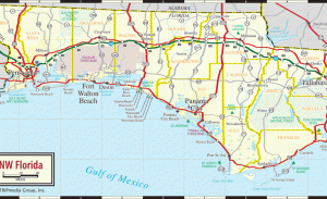
A Panhandle Florida road map is essential for navigating the region’s highways, scenic routes, and coastal byways.
Major Highways
- US 98: Runs parallel to the Gulf Coast, connecting Pensacola, Destin, Panama City Beach, and Apalachicola.
- I-10: A major east-west interstate linking Pensacola to Tallahassee, with exits for key towns like Crestview and Marianna.
- SR 30A: A scenic coastal route through Walton County, passing through beach towns like Seaside and Rosemary Beach.
Scenic Drives
- Emerald Coast Parkway: Part of US 98, offering stunning Gulf views between Destin and Fort Walton Beach.
- Gulf Coast Scenic Highway: In Franklin County, provides access to St. George Island and Carrabelle’s historic waterfront.
- Blackwater Heritage State Trail: A paved trail near Milton, ideal for biking or driving to nearby parks.
Travel Tips
- Navigation: Use a Florida Panhandle road map to plan stops at beaches, restaurants, and attractions along US 98.
- Traffic: Summer months see heavier traffic, especially near Destin and Panama City Beach; plan for early morning or late afternoon travel.
- Access: Smaller roads like SR 20 connect inland areas, offering quieter routes to towns like Niceville and Freeport.
This Panhandle Florida road map ensures easy navigation for road trips and day excursions.
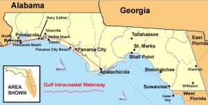
Florida Gulf Coast Map
A Florida Gulf Coast map emphasizes the Panhandle’s stunning shoreline, highlighting beaches, barrier islands, and coastal attractions.
Key Coastal Areas
- Pensacola Beach: On Santa Rosa Island, known for its white sands and vibrant boardwalk.
- Destin and Miramar Beach: Famous for crystal-clear waters and fishing opportunities near Choctawhatchee Bay.
- Panama City Beach: Offers 27 miles of beaches, with St. Andrews State Park as a natural highlight.
Barrier Islands
- Santa Rosa Island: Home to Pensacola Beach and Navarre Beach, with protected areas like Gulf Islands National Seashore.
- St. George Island: In Franklin County, known for its quiet beaches and state park.
- Okaloosa Island: Near Fort Walton Beach, offering family-friendly beaches and water sports.
Coastal Features
- Bays and Inlets: Includes Pensacola Bay, St. Andrews Bay, and Apalachicola Bay, key for boating and fishing.
- Parks: Highlights coastal parks like Henderson Beach State Park and St. Joseph Peninsula State Park.
- Activities: Marks spots for kayaking, paddleboarding, and dolphin tours, especially near Destin and Apalachicola.
This Florida Gulf Coast map showcases the Panhandle’s coastal beauty, guiding visitors to its best beaches and water activities.
Panhandle FL Beach Towns Map
A Panhandle FL beach towns map focuses on the region’s charming coastal communities, each with distinct vibes and attractions.
Navarre Beach
- Location: In Santa Rosa County, between Pensacola and Fort Walton Beach.
- Features: Known as “Florida’s Most Relaxing Place,” with quiet beaches and a marine sanctuary for snorkeling.
- Map Notes: Accessible via US 98 and the Navarre Beach Causeway.
Seaside
- Location: In Walton County, along the scenic SR 30A corridor.
- Features: A master-planned community with pastel-colored homes, boutique shops, and Grayton Beach nearby.
- Map Notes: Located near Rosemary Beach and WaterColor, ideal for exploring multiple towns.
Mexico Beach
- Location: In Bay County, east of Panama City Beach.
- Features: A quieter alternative with soft sands and a small-town feel, perfect for fishing and relaxation.
- Map Notes: Reachable via US 98, with proximity to Port St. Joe and Cape San Blas.
This Panhandle FL beach towns map helps visitors discover the unique character of each coastal community.
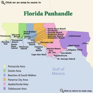
Interactive Map of FL Panhandle
An interactive map of FL Panhandle offers dynamic features, allowing users to zoom, click, and explore real-time information.
Key Features
- Zoom and Pan: Enables detailed views of towns, beaches, and attractions, from Pensacola to Apalachicola.
- Points of Interest: Includes clickable markers for restaurants, hotels, and parks, with details like hours and reviews.
- Route Planning: Allows users to calculate driving routes along US 98 or I-10, factoring in traffic and distance.
Benefits
- Customization: Users can filter for specific interests, like beaches, historic sites, or dining options.
- Real-Time Data: Provides updates on road conditions, weather, and events, enhancing travel planning.
- Accessibility: Available on mobile devices or desktops, ideal for on-the-go navigation.
Popular Uses
- Vacation Planning: Helps identify attractions near FL Panhandle vacation map destinations like Destin or Panama City Beach.
- Outdoor Exploration: Marks trails, fishing spots, and kayak launches for adventure seekers.
- Event Tracking: Highlights festivals like the Pensacola Seafood Festival or Destin Fishing Rodeo.
An interactive Florida Panhandle map is a powerful tool for seamless exploration of the region.
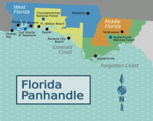
Map of Counties in Florida Panhandle
A map of counties in Florida Panhandle outlines the eight counties that define the region, each with distinct characteristics.
Escambia County
- Key Cities: Pensacola, Century.
- Features: Home to Pensacola Beach, Gulf Islands National Seashore, and historic downtown Pensacola.
- Map Notes: Westernmost county, bordered by Alabama, accessible via I-10 and US 29.
Okaloosa County
- Key Cities: Destin, Fort Walton Beach, Niceville.
- Features: Includes Choctawhatchee Bay, Eglin Air Force Base, and Henderson Beach State Park.
- Map Notes: Centrally located, with US 98 and SR 293 (Mid-Bay Bridge) as major routes.
Bay County
- Key Cities: Panama City, Panama City Beach.
- Features: Known for St. Andrews Bay, Pier Park, and 27 miles of beaches.
- Map Notes: Connected by US 98 and SR 77, with Panama City as a commercial hub.
Other Counties
- Santa Rosa: Home to Navarre Beach and Milton, accessible via US 90.
- Walton: Includes Seaside, Rosemary Beach, and Topsail Hill Preserve, along SR 30A.
- Gulf, Franklin, Wakulla: Feature quieter towns like Port St. Joe, Apalachicola, and St. Marks, with coastal and forest attractions.
This Panhandle FL county map provides a clear view of the region’s administrative boundaries and key destinations.
FL Panhandle Vacation Map
A FL Panhandle vacation map is tailored for tourists, highlighting attractions, accommodations, and activities.
Key Attractions
- Pensacola: Naval Aviation Museum, Fort Pickens, and Blue Wahoos Stadium.
- Destin: Destin Harbor Boardwalk, deep-sea fishing, and Crab Island.
- Panama City Beach: St. Andrews State Park, Shell Island, and water sports.
Accommodations
- Resorts: Marks properties like Hilton Sandestin, WaterColor Inn, and Portofino Island Resort.
- Campgrounds: Includes Camping on the Gulf in Destin and St. George Island State Park.
- Vacation Rentals: Notes areas like Miramar Beach and Seaside for condo and home rentals.
Activities
- Beaches: Highlights public access points like Pensacola Beach and Grayton Beach.
- Outdoor Adventures: Marks kayak launches, hiking trails, and snorkeling spots.
- Cultural Sites: Includes historic districts in Pensacola and Apalachicola.
This Florida Panhandle travel guide map simplifies vacation planning, ensuring a well-rounded trip.
Florida Panhandle Towns and Highways
A Florida Panhandle towns and highways map emphasizes connectivity between communities and major routes.
Key Towns
- Crestview: In Okaloosa County, a growing hub along I-10, known for its historic downtown.
- DeFuniak Springs: In Walton County, home to Lake DeFuniak and Victorian-era homes.
- Port St. Joe: In Gulf County, a quiet coastal town with access to Cape San Blas.
Major Highways
- US 98: The primary coastal route, linking all major beach towns from Pensacola to Apalachicola.
- I-10: Connects inland cities like Crestview, Marianna, and Tallahassee, ideal for cross-Panhandle travel.
- SR 20: Runs through rural areas, connecting Freeport, Niceville, and Ebro.
Map Features
- Rest Stops and Services: Notes gas stations, rest areas, and visitor centers along I-10 and US 98.
- Scenic Routes: Highlights SR 30A for its picturesque coastal drive through Walton County.
- Towns: Marks smaller communities like Carrabelle, Sopchoppy, and Wewahitchka for off-the-beaten-path exploration.
This map of towns in Florida Panhandle ensures travelers can navigate both popular and hidden gems.
FAQs About Map FL Panhandle
1. What does a Florida Panhandle map include?
A Florida Panhandle map covers eight counties, major cities like Pensacola and Destin, highways like US 98 and I-10, and coastal features like beaches and bays.
2. Which cities are shown on a FL Panhandle city map?
A FL Panhandle city map highlights Pensacola, Destin, Fort Walton Beach, Panama City Beach, and Apalachicola, among others, with key attractions and access routes.
3. How can a detailed FL Panhandle map help with travel planning?
A detailed FL Panhandle map shows smaller towns, state parks, rivers, and secondary roads, helping travelers plan visits to places like Navarre Beach or Apalachicola National Forest.
4. What highways are featured on a Panhandle Florida road map?
A Panhandle Florida road map includes US 98 along the coast, I-10 for inland travel, and SR 30A for scenic coastal drives through beach towns.
5. What are the best beach towns on a Panhandle FL beach towns map?
A Panhandle FL beach towns map features Navarre Beach, Seaside, Mexico Beach, and Pensacola Beach, each with unique coastal attractions.
6. How does an interactive map of FL Panhandle enhance travel?
An interactive map of FL Panhandle offers zoomable views, clickable points for attractions, and real-time data like traffic and weather, ideal for dynamic trip planning.
7. What counties are included in a map of counties in Florida Panhandle?
A map of counties in Florida Panhandle includes Escambia, Santa Rosa, Okaloosa, Walton, Bay, Gulf, Franklin, and Wakulla, each with distinct towns and features.
Conclusion on Map FL Panhandle
A Map FL Panhandle unlocks the beauty and diversity of Northwest Florida, guiding travelers through its stunning Gulf Coast, vibrant towns, and natural wonders. From the FL Panhandle city map highlighting Destin and Pensacola to the Panhandle FL beach towns map showcasing Seaside and Mexico Beach, these maps provide essential tools for exploration.
Whether using a detailed FL Panhandle map to discover state parks or a Florida Panhandle road map to navigate US 98, the region’s accessibility and charm shine through. With interactive Florida Panhandle map options for real-time planning and FL Panhandle vacation map features for tourist attractions, the Panhandle invites visitors to experience its beaches, history, and culture with ease and excitement.